Potential actions of FDGC

Honoring the rich history and bright future of gliding at Dockweiler Beach

Potential actions of FDGC

Postby JoeF » Wed Jun 03, 2015 11:26 am

Potential actions by FDGC members
Brainstorming over the topic, all are welcome:

Start:
== Pick up and remove sporadic rocks that feet or toes may hit.
== Study and report on hydrophobic treatment of wing surfaces.
== Make digital maps showing various ways of getting to the Dockweiler Flight Training Park (walk, bike, bus, car, train-and-bus, LAX to park, etc.)
== Explore parking in El Segundo and then finishing the pathing to the park by various means: bus, walk, car pool, ...
== Explore tensed running sheets for possible occasional placement in sand slopes.
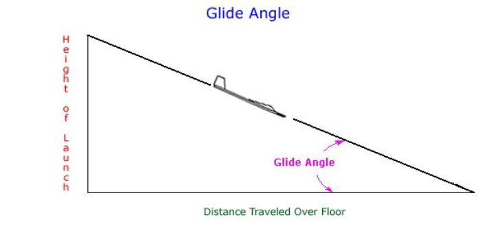
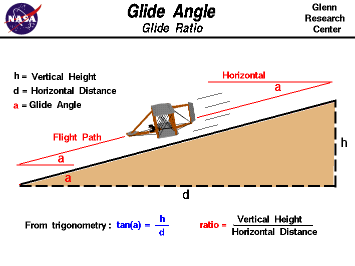
== Find ways to know the actual height of the launching points relative to the landing poings. No more guessing! We have seen estimates from 18 ft to 50 ft; just what are the actual heights. Some surveying? And in real time?
== Find ways to well report close actual weather and wind and temperature ... and at various points. How aware could it all get?
== Ask Windsports what would be helpful with regard to placing sand. Discover the goals of Windsports with respect to keeping the slopes groomed and shaped.
== Clean debris that arrives to the designated areas.
== Move sand off the bike way, plaque patio, and walkways.
== Advance the Dockweiler history notes in our FDGC forum sector
== Sign up and schedule a formal training lesson from Windsports' instructors
== Spread FDGC presence to obtain best balance with Windsports instruction process. There are five days a week to receive FDGC members.
== Just outside the borders of flight-activity-designated areas are park open areas and Pacific Ocean; such areas may be used for
FDGC members for supportive and secondary activities:
++++++++ rest
++++++++ picnic
++++++++ toss toys
++++++++ swimming
++++++++ surfing
++++++++ running
++++++++ tumbling
++++++++ talking
++++++++ walking
++++++++ singing
++++++++ dancing
++++++++ sand sliding
++++++++ sand arts
++++++++ planning gliding actions
++++++++ solving gliding challenges
++++++++ studying science and mathematics of gliding
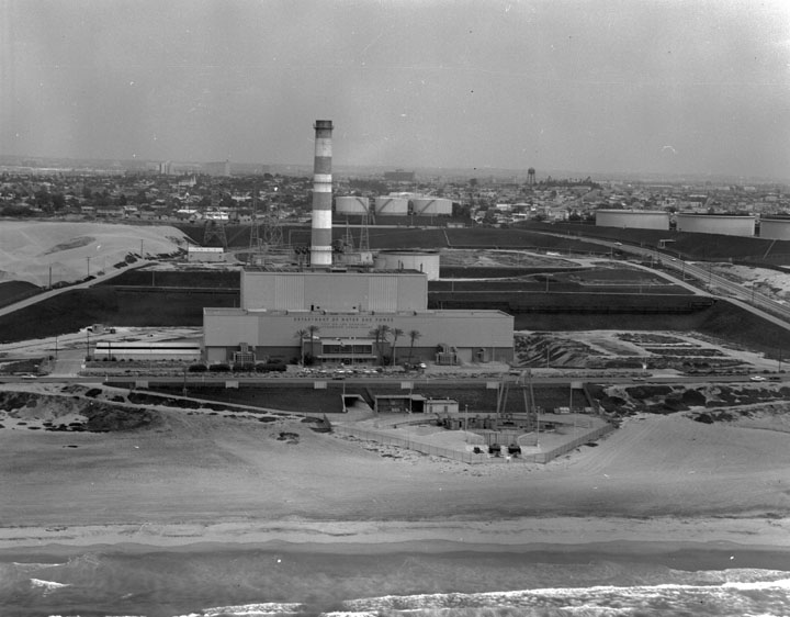
++++++++ toy-kite flying under the altitude shield of the Scattergood plant towers south of the Dockweiler Beach Flight Training Park
++++++++ model hand-toss gliding experiments
++++++++ gear study
++++++++ gear display
++++++++ sand-tensed-sheet experimentation for wing running and safe-splat experimentation
++++++++ reading about gliding
++++++++ Trek to the north restroom
++++++++ Trek to the south Grand Ave. parking lot outhouses
++++++++ fishing (as permitted)
++++++++ sand running
++++++++ wing running
++++++++ build wings
++++++++ play
++++++++ hop
++++++++ hope
++++++++ leap
++++++++ skip
++++++++ drink water

+++++++++++++++ ????? +

Image

Image
Image

SOME RELATED IMAGES AND TEXT:
== http://jalcornphoto.photoshelter.com/im ... rUvYfUPFaM
==
==
== ??
Join a National Hang Gliding Organization: US Hawks at ushawks.org

View pilots' hang gliding rating at: US Hang Gliding Rating System
User avatar
JoeF
Contributor
Contributor
 
Posts: 4688
Joined: Sat Aug 14, 2010 3:41 pm

Topography of Dockweiler Flight Training Site

Postby JoeF » Sat Jun 06, 2015 7:03 pm

PotentialEnergyPerLaunch.png
PotentialEnergyPerLaunch.png (2.26 KiB) Viewed 8769 times

Available potential energy at each launch at Dockweiler

The several launch points are at a certain altitude above the sands below. The sand below has its own shape and altitude. The altitude of the launch above the sand below provides the vertical distance for generating potential energy for use in gliding. Multiply the gross take-off weight (mg) by the difference of the two involved altitudes. http://en.wikipedia.org/wiki/Potential_energy


Consider a full calm with no slope lift from the wind. And, especially for flights after the first flight, the pilot usually is the one who climbs up the slope to produce the energy that would be used. Feel neat about generating the potential energy for your next flight! :thumbup: :clap:

Just what is the topography for each of six or so launch points? There are in the literature various guesses from 15 ft to 50 ft, but such guesses do not settle the question for each launch. It may be fun to know precisely the exact topography for each launch over its frontal landing apron. What are some low cost methods to have the accurate topographical profile for each launch? The graphics for each launch and its associated landing apron could be available in our forum.

hT Launch _______
h --
h --

h0 ___________________landing apron
Join a National Hang Gliding Organization: US Hawks at ushawks.org

View pilots' hang gliding rating at: US Hang Gliding Rating System
User avatar
JoeF
Contributor
Contributor
 
Posts: 4688
Joined: Sat Aug 14, 2010 3:41 pm

Eyeball Method: June 7,2015: 24 ft net drop to LZ sand

Postby JoeF » Tue Jun 09, 2015 5:42 am

On June 7, 2015, a member of FDGC used a self-height eyeball glancing method to measure the topography of one of the north launches. He sensed "level" and went down the slope until the relatively flat apron at launch was just disappearing; mark in the sand on the slope: M1 with some visual reference. That gave one drop of about 6 ft. Then going down the slope until M1 is glanced at sensed "level" eye glace, and mark slope sand with M2. Now about 12 ft. was accumulated. Going further for similar method and glancing with eye at the M2, set M3. Now about 18 ft. Well, to get a "level" glance again took some going. Far out in the LZ after a dimple in the sand and then some rise, perhaps an M4 was sensed, but not more. Thus, four instances of about 6 ft for a net 24 ft drop. The "dimple in the sand occurs for perhaps several reasons; one would need to know just how beach authorities may have moved sand, or how the wind is forming the LZ sand; there is a near-water rise in the sand level just before the wet decline to ocean water. The undulating shape of the LZ tested with soap bubbles indicates a slight rotor or quiet zone in the dimple that is often also sensed during straight glides off the the slope. Grooming a straight LZ apron without the dimple would take a conscious effort by a tractor. There is definitely not an "always" rising cross section from the ocean water to the top of the slope to launch points.

From the eye-glance step method, we may go into other methods. All, method methods and perhaps arrive and perform a method. Publish results? Standard survey instruments? Altimeter and tape measure? Taut catenary string and friction-aware timed roller on string combined with photographic method? Trigonometric methods (various tactics)?

Dimple fillers? Empty your sneakers into the dimple? 8-) See how you might improve on the 24 ft estimate! While your friend is taking lessons from Greg, try out some site-description method. Have fun.

The launch points have an absolute distance from the center of the earth (which is not a constant position in the fine, but often taken as a static reference point); similarly, the point of landing on the LZ will vary per flight; if one lands at the top of a berm, then that is different from landing in the bottom of a dimple.
Join a National Hang Gliding Organization: US Hawks at ushawks.org

View pilots' hang gliding rating at: US Hang Gliding Rating System
User avatar
JoeF
Contributor
Contributor
 
Posts: 4688
Joined: Sat Aug 14, 2010 3:41 pm

Re: Potential actions of FDGC

Postby JoeF » Tue Jun 09, 2015 7:00 am

Click photo to see full tallness of the photo:
WindGradientTowerKiteSystemApplication.png
WindGradientTowerKiteSystemApplication.png (306.93 KiB) Viewed 8746 times

Near Dockweiler Hang Gliding Center but outside the HG flight zone:
Measuring wind gradient and its changes?

How would standardized tell-tails work? Have a set of 20 tell-tails that would flap characteristically to a certain wind speed. Then a distant visual might delight.

Maybe have some rotors that would autorotate at various speeds; the rotation rate could give data in various ways.

http://en.wikipedia.org/wiki/Autorotati ... g_aircraft)#Autorotation_in_kites_and_gliders
http://en.wikipedia.org/wiki/Autorotation
Join a National Hang Gliding Organization: US Hawks at ushawks.org

View pilots' hang gliding rating at: US Hang Gliding Rating System
User avatar
JoeF
Contributor
Contributor
 
Posts: 4688
Joined: Sat Aug 14, 2010 3:41 pm

Re: Topography of Dockweiler Flight Training Site

Postby Bill Cummings » Tue Jun 09, 2015 12:46 pm

JoeF wrote:
The attachment PotentialEnergyPerLaunch.png is no longer available

Available potential energy at each launch at Dockweiler

The several launch points are at a certain altitude above the sands below. The sand below has its own shape and altitude. The altitude of the launch above the sand below provides the vertical distance for generating potential energy for use in gliding. Multiply the gross take-off weight (mg) by the difference of the two involved altitudes. http://en.wikipedia.org/wiki/Potential_energy


Consider a full calm with no slope lift from the wind. And, especially for flights after the first flight, the pilot usually is the one who climbs up the slope to produce the energy that would be used. Feel neat about generating the potential energy for your next flight! :thumbup: :clap:

Just what is the topography for each of six or so launch points? There are in the literature various guesses from 15 ft to 50 ft, but such guesses do not settle the question for each launch. It may be fun to know precisely the exact topography for each launch over its frontal landing apron. What are some low cost methods to have the accurate topographical profile for each launch? The graphics for each launch and its associated landing apron could be available in our forum.

hT Launch _______
h --
h --

h0 ___________________landing apron

Hey Joe I forgot now the math I used to figure out the angle of a soaring slope, height and everything else but I remember (except for the numbers) how I went about it.
Tools used:
Combination angle, level, and adjustable square.
Measuring tape.
Calculator. (capable of sine, cosine, tangent.)

Bubble level with horizon. (by friend out to your side)
Sight down slope of the hill. (by you and tighten the screws to fix the angle.)
Read the angle and distance down the slope and go back thirty years to when you remembered how to load this into the calculator.
How about it Bob? Do you still remember how? I sure don’t! :roll: :?: :think:
You may have to hit control plus (+) to blow up the attachment to read it.
Measure the sand dune.JPG
Measure the sand dune.JPG (46.46 KiB) Viewed 8739 times
User avatar
Bill Cummings
Contributor
Contributor
 
Posts: 3360
Joined: Wed Jul 13, 2011 6:20 pm
Location: Las Cruces NM 88005 (Region 4)

Soil slope vs glide-path slope

Postby JoeF » Tue Jun 09, 2015 1:28 pm

Good, BillC, the slope of the earth slope is a fun parameter, as the wind is redirected by the soil earth slope. Knowing the soil slope plays a part in just how the wind is redirected. And in calm, one may have fun knowing the earth slope in order to plan ground skimming or gliding to leave the ground-effect realm, pending L/D of the gliding-kite system being used.

Another non-soil slope in calm air is the glide path at Dockweiler; say in full calm one gets off the launch and glides straight out toward some point on the sand; will one glide to the point or settle for a closer or further point? When going for distance in that calm, one will reach a point that is lower than the launch point; between those two points will be a relatively straight line through the calm air, but not perfectly straight, as some ground-effect occurs at launch and then again at landing; but a normalized glide path may be figured by the two points and the net altitude drop. Projected distance (zenithal shadow of the glide path) is a number; this is one leg of an involved right triangle. Knowing the altitude drop from launch to the landing is the other leg of the right triangle.
Image

Image

E.g., say Dockweiler is 25 ft at launch ---above landing altitude. Say floor distance traveled is 175 ft. Let G be the glide angle: tangent G= 25/175= 1/7= 0.143 approx.

Another method is to use your angle method; get the angle of glide using the level sighting. So, get G by that method; say the arc read about 8 degrees. Then tangent (8)= 0.143 approx.
Join a National Hang Gliding Organization: US Hawks at ushawks.org

View pilots' hang gliding rating at: US Hang Gliding Rating System
User avatar
JoeF
Contributor
Contributor
 
Posts: 4688
Joined: Sat Aug 14, 2010 3:41 pm

Re: Potential actions of FDGC

Postby Bill Cummings » Tue Jun 09, 2015 3:36 pm

Find heigth knowing hypotenuse and slope angle.JPG
Find heigth knowing hypotenuse and slope angle.JPG (7.33 KiB) Viewed 8702 times

How to.JPG
How to.JPG (29.84 KiB) Viewed 8702 times
User avatar
Bill Cummings
Contributor
Contributor
 
Posts: 3360
Joined: Wed Jul 13, 2011 6:20 pm
Location: Las Cruces NM 88005 (Region 4)

Re: Potential actions of FDGC

Postby JoeF » Tue Jun 09, 2015 10:57 pm

BillC,
So, with that method, to know the "1000" or equivalent hypotenuse, one could at Dockweiler get a string from landing point to launch point; make the string taut. Neglect the small catenary. Measure the string. Then from your first post get the angle from down vertical to the glide path, to match what the 60 deg was playing in your example drawing. Then the h could be determined. Since Dockweiler is about 25 ft in first guesstimate from June 7, 2015, then playing with about 82 degrees, cos 82=0.139 approx. 25/s=0.139 for 25/0.139=s for s=180 ft approx. So, we would need a working string of about 200 ft with markings at each foot in the region likely to be used, longer if anticipated glide is better than about 7 to 1.

Then, one sets up your inclinometer at launch or at landing to get the angle wanted. Then stretch the string from landing to launch point; mark the string; read the length of the hypotenuse. Then calculate the height of the launch above the landing as above for h.

For various inclinometer images: HERE
=======================

Other trig methods with a base segment and two separate angle readings and some fancier trigonometry will give h without using a long string; such method may soon be described in this discussion.
Join a National Hang Gliding Organization: US Hawks at ushawks.org

View pilots' hang gliding rating at: US Hang Gliding Rating System
User avatar
JoeF
Contributor
Contributor
 
Posts: 4688
Joined: Sat Aug 14, 2010 3:41 pm

Re: Potential actions of FDGC

Postby JoeF » Tue Jun 09, 2015 11:08 pm

Measuring the Dockweiler launch height over landing height by indirect method:
This method needs a level handy segment at the LZ; at each end of the handy level segment, take individual angle readings.

Trigonometry - Find the height of a mountain. MathematicsClass.com (10b)


Once the height of the launch is known well, then that h may be used to find the glide angles of real flights; see posts above by BillC and Joe.


==================================
Angle of Elevation/Angle of Depression Problems
Join a National Hang Gliding Organization: US Hawks at ushawks.org

View pilots' hang gliding rating at: US Hang Gliding Rating System
User avatar
JoeF
Contributor
Contributor
 
Posts: 4688
Joined: Sat Aug 14, 2010 3:41 pm

Re: Potential actions of FDGC

Postby Bob Kuczewski » Wed Jun 10, 2015 1:14 am

JoeF wrote:Once the height of the launch is known well, then that h may be used to find the glide angles of real flights; see posts above by BillC and Joe.


Something tells me that my next visit to Dockweiler is going to require . . . a slide-rule!!!

:srofl:
Join a National Hang Gliding Organization: US Hawks at ushawks.org
View my rating at: US Hang Gliding Rating System
Every human at every point in history has an opportunity to choose courage over cowardice. Look around and you will find that opportunity in your own time.
User avatar
Bob Kuczewski
Contributor
Contributor
 
Posts: 8515
Joined: Fri Aug 13, 2010 2:40 pm
Location: San Diego, CA

Next

Return to Friends of Dockweiler Gliding Society

Who is online

Users browsing this forum: No registered users and 52 guests

cron