Maps of Interest related to Dockweiler HGFTC (hang gliding flight training center)
This topic thread is introduced as a result of Way #90 in the 1000 ways to be a friend to Dockweiler gliding.
Post links to maps that seem to add something to the Dockweiler flying experience. Comment on the maps and reasons.
Friends of Dockweiler Gliding Society
Honoring the rich history and bright future of gliding at Dockweiler Beach
Maps of Interest related to Dockweiler HGFTC
9 posts
• Page 1 of 1
Maps of Interest related to Dockweiler HGFTC
![]() by JoeF » Mon Jul 13, 2015 8:14 am
by JoeF » Mon Jul 13, 2015 8:14 am
Join a National Hang Gliding Organization: US Hawks at ushawks.org
View pilots' hang gliding rating at: US Hang Gliding Rating System
View pilots' hang gliding rating at: US Hang Gliding Rating System
-

JoeF - Contributor

- Posts: 4283
- Joined: Sat Aug 14, 2010 3:41 pm
Re: Maps of Interest related to Dockweiler HGFTC
![]() by JoeF » Wed Jan 27, 2016 8:26 am
by JoeF » Wed Jan 27, 2016 8:26 am
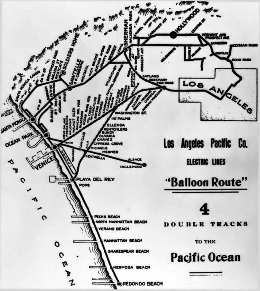
Dept. of Water and Power wrote:(1910)** - Map of the Los Angeles Pacific Company Electric lines around Los Angeles, including the "Balloon Route" which would bring flocks of tourists to Santa Monica, among other places.
Historical Notes
The Balloon Route Trolley trip was the featured route of the Los Angeles Pacific, opened in September 1901. The line ran from downtown LA through Hollywood, Santa Monica, Venice Beach, Redondo Beach and back to L.A. via Culver City. The lines stopped at beach resorts and included free entrance to some en-route stops attractions along the way, including: Sunset Boulevard, studio of painter Paul de Longpré, bean fields of Morocco in Beverly Hills, Sawtelle Veterans Home and Old Soldiers' Home in Sawtelle, Long Wharf, Camera Obscura at Santa Monica, Playa del Rey Pavilion for a fish dinner, Redondo's Moonstone Beach, Venice, and Palms - Culver City.*^
South of Dockweiler on the 1910 map is "Pecks Beach" (sic, Peck's Beach). How far south? History? So far, the only note I can find that may relate to the above map's note of "Pecks Beach" is in a wiki: "George H. Peck owned a lot of the land that became part of the north section of Manhattan Beach."
https://en.wikipedia.org/wiki/Manhattan_Beach,_California
I am guessing that the more one would know about George, the more about the Pecks Beach might be discovered. I am guessing that the map had a typo; I'd go for "Peck's Beach". And lo: https://en.wikipedia.org/wiki/George_H._Peck
And wow, more: Peck's Pier and Pavilion ... https://en.wikipedia.org/wiki/Peck%27s_Pier_and_Pavilion
In that south direction is a contemporary park with a monument "Bruce's Beach" which clues to some unfortunate area racism history: http://www.plazanoir.com/erasing-a-line-drawn-in-the-sand/. Sometimes when I fly a hang glider at Dockweiler with a south heading, I aim to recall how sinking air for anyone is a sinking air for all. The plaque at the little park is set back a block or so from the sand; riding a bike on the Marvin Braude Bikeway from Dockweiler is one way to visit the plaque. I aim to do a micro hang glide at the park in memory of those whose recreational freedoms were damped unjustly. Some contemporary images. There is a missing photo; the missing might be healed one day: a hang glider in flight at that park as a sign of hope for erasing lines in the sand.
A pop-up hang glider flight could be achieved on that slope.
One for all-time memory! May such injustices never be repeated.
https://en.wikipedia.org/wiki/Bruce%27s_Beach
Article: http://upfromslavery.com/brucesbeach/
=================================================================
Going north of Dockweiler, find Playa Del Rey, Venice, Santa Monica, Malibu.
A rich photo site regarding early Santa Monica: [urlhttp://waterandpower.org/museum/Early_Views_of_Santa_Monica.html]http://waterandpower.org/museum/Early_Views_of_Santa_Monica.html[/url]
=================================================================
The Manhattan Beach area south of our hang gliding has some history. A start teaser for such might be the wiki
https://en.wikipedia.org/wiki/Manhattan_Beach_Pier where one finds that an early name for the area was Potencia.
=================================
More on "Balloon Route" is an early map (date? [ ] ) HERE in PDF
In another historical document, I have clipped a train schedule that took people to "Hyperion" where sand dunes would be seen, the roots of our Dockweiler flying site.
- http://www.pacificelectric.org/pacific-electric/western-district/daily-balloon-route-excursion-brochure-1910/
- BalloonRouteHYPERION.JPG (27.33 KiB) Viewed 7048 times
Today: no such train. And bus service is extremely scanty; the car, bike, and hike are the means to get to Dockweiler. Or bus into El Segundo and hike down Grand Ave. Year 1910: parlour train car rides to "Hyperion" would do; I wonder if anyone in 1910 used the dunes there for hang gliding.
https://en.wikipedia.org/wiki/Los_Angeles_Pacific_Railroad
Then Red Car: https://en.wikipedia.org/wiki/Pacific_Electric
http://www.erha.org/balloon.htm
- Attachments
-
- PECKSBEACHmap.JPG (16.39 KiB) Viewed 7047 times
Join a National Hang Gliding Organization: US Hawks at ushawks.org
View pilots' hang gliding rating at: US Hang Gliding Rating System
View pilots' hang gliding rating at: US Hang Gliding Rating System
-
JoeF - Contributor
- Posts: 4283
- Joined: Sat Aug 14, 2010 3:41 pm
Re: Maps of Interest related to Dockweiler HGFTC
![]() by JoeF » Wed Jan 27, 2016 1:42 pm
by JoeF » Wed Jan 27, 2016 1:42 pm
Researchers might consider the holdings:
http://www.oac.cdlib.org/findaid/ark:/13030/kt1v19q6qk/entire_text/
========================================================
Close, but unknown:
=================================================
Clip from a 1920 circa map with some "relief" and with Pacific Electric line along the beach:
Note: Just north of Hyperion on a map is "Holton" for which I've no information. [ ]
[ ]
http://www.oac.cdlib.org/findaid/ark:/13030/kt1v19q6qk/entire_text/
========================================================
Close, but unknown:
http://www.uncanny.net/~wetzel/redondo.htm wrote:
The next photo was taken somewhere south of Playa Del Rey. The Redondo via Playa del Rey line ran along the beach from Playa Del Rey to the north edge of Hermosa Beach, where it moved a block or so inland.

=================================================
Clip from a 1920 circa map with some "relief" and with Pacific Electric line along the beach:
- PacificElectric19220circa.JPG (44.91 KiB) Viewed 7041 times
- PacificElectric19220circaBB.JPG (43.19 KiB) Viewed 7041 times
Note: Just north of Hyperion on a map is "Holton" for which I've no information. [ ]
- On a 1907 map there is a "POPE" for which I have no information.
- POPEof1907mapRail.JPG (17.2 KiB) Viewed 7041 times
Join a National Hang Gliding Organization: US Hawks at ushawks.org
View pilots' hang gliding rating at: US Hang Gliding Rating System
View pilots' hang gliding rating at: US Hang Gliding Rating System
-
JoeF - Contributor
- Posts: 4283
- Joined: Sat Aug 14, 2010 3:41 pm
Re: Maps of Interest related to Dockweiler HGFTC
![]() by JoeF » Wed Jan 27, 2016 5:07 pm
by JoeF » Wed Jan 27, 2016 5:07 pm
- SatelliteDOCKWEILER.JPG (30.74 KiB) Viewed 7037 times
Contemporary satellite image
Google. 2016
Join a National Hang Gliding Organization: US Hawks at ushawks.org
View pilots' hang gliding rating at: US Hang Gliding Rating System
View pilots' hang gliding rating at: US Hang Gliding Rating System
-
JoeF - Contributor
- Posts: 4283
- Joined: Sat Aug 14, 2010 3:41 pm
Re: Maps of Interest related to Dockweiler HGFTC
![]() by JoeF » Wed Jan 27, 2016 5:22 pm
by JoeF » Wed Jan 27, 2016 5:22 pm
Holton was an early settlement just north of Dockweiler Hang Gliding Park.
https://en.wikipedia.org/wiki/Holton,_California
Holton is historical settlement place.
http://geonames.usgs.gov/apex/f?p=gnispq:3:0::NO::P3_FID:1669976
Who settled in Holton back then? Did they fly hang gliders?
================================
Map tool placement of Holton at a point just seaward of an LAX runway:
A firm walk north of hang glider park at Dockweiler.
Fenced. Old streets paved. Do not disturb LAX traffic with any activity there.
Airport police would arrive in minutes.
https://en.wikipedia.org/wiki/Holton,_California
Holton is historical settlement place.
http://geonames.usgs.gov/apex/f?p=gnispq:3:0::NO::P3_FID:1669976
- HoltonMap.png (22.37 KiB) Viewed 7037 times
Who settled in Holton back then? Did they fly hang gliders?
================================
Map tool placement of Holton at a point just seaward of an LAX runway:
- HoltonPerMapTool.JPG (73.43 KiB) Viewed 7035 times
A firm walk north of hang glider park at Dockweiler.
Fenced. Old streets paved. Do not disturb LAX traffic with any activity there.
Airport police would arrive in minutes.
Last edited by JoeF on Wed Jan 27, 2016 6:28 pm, edited 1 time in total.
Join a National Hang Gliding Organization: US Hawks at ushawks.org
View pilots' hang gliding rating at: US Hang Gliding Rating System
View pilots' hang gliding rating at: US Hang Gliding Rating System
-
JoeF - Contributor
- Posts: 4283
- Joined: Sat Aug 14, 2010 3:41 pm
Re: Maps of Interest related to Dockweiler HGFTC
![]() by JoeF » Wed Jan 27, 2016 6:05 pm
by JoeF » Wed Jan 27, 2016 6:05 pm
http://aerialarchives.photoshelter.com/ ... biSSnEj86c
Aerial image copyrighted.
Dockweiler beachward of Hyperion plant.
Aerial image copyrighted.
Dockweiler beachward of Hyperion plant.
Join a National Hang Gliding Organization: US Hawks at ushawks.org
View pilots' hang gliding rating at: US Hang Gliding Rating System
View pilots' hang gliding rating at: US Hang Gliding Rating System
-
JoeF - Contributor
- Posts: 4283
- Joined: Sat Aug 14, 2010 3:41 pm
Re: Maps of Interest related to Dockweiler HGFTC
![]() by Frank Colver » Wed Jan 27, 2016 10:39 pm
by Frank Colver » Wed Jan 27, 2016 10:39 pm
Last year, when I looked at the Google Earth image of the Dockweiler Beach area, before the Otto 44th anniversary meet, there was a WW Condor visible in the image. It was set up in the teaching area. The latest image I get now didn't catch a glider when it was taken.
FC
FC
-
Frank Colver - Contributor
- Posts: 1285
- Joined: Tue May 24, 2011 11:21 am
Re: Maps of Interest related to Dockweiler HGFTC
![]() by wingspan33 » Thu Jan 28, 2016 10:55 pm
by wingspan33 » Thu Jan 28, 2016 10:55 pm
Joe,
Thanks for the Dockweiler Beach history in maps. Oddly, I didn't even know while I visited this last May that I was so close to Redondo Beach, LA. Being a big and long time Beach Boys fan, a couple day ago I was listening to one of their songs (Surfin' Safari) that mentions that beach. If I knew how to (water) surf, I could have both water and sky surfed while I was out there on the left coast. Either way, it's great to see some map history regarding the site.
Thanks for the Dockweiler Beach history in maps. Oddly, I didn't even know while I visited this last May that I was so close to Redondo Beach, LA. Being a big and long time Beach Boys fan, a couple day ago I was listening to one of their songs (Surfin' Safari) that mentions that beach. If I knew how to (water) surf, I could have both water and sky surfed while I was out there on the left coast. Either way, it's great to see some map history regarding the site.
-

wingspan33 - Contributor
- Posts: 1150
- Joined: Fri Aug 13, 2010 8:24 pm
Re: Maps of Interest related to Dockweiler HGFTC
![]() by JoeF » Sun Feb 14, 2016 4:51 pm
by JoeF » Sun Feb 14, 2016 4:51 pm
Join a National Hang Gliding Organization: US Hawks at ushawks.org
View pilots' hang gliding rating at: US Hang Gliding Rating System
View pilots' hang gliding rating at: US Hang Gliding Rating System
-
JoeF - Contributor
- Posts: 4283
- Joined: Sat Aug 14, 2010 3:41 pm
9 posts
• Page 1 of 1
Return to Friends of Dockweiler Gliding Society
Who is online
Users browsing this forum: No registered users and 9 guests